MizarVision Watcher @MizarVision
Independent OSINT & imagery analysis | satellite imagery, flight tracking, defence news. Unofficial commentary account. Not affiliated with MizarVision Old Town - Chinatown, Portland Joined January 2026-
Tweets453
-
Followers14K
-
Following0
-
Likes24
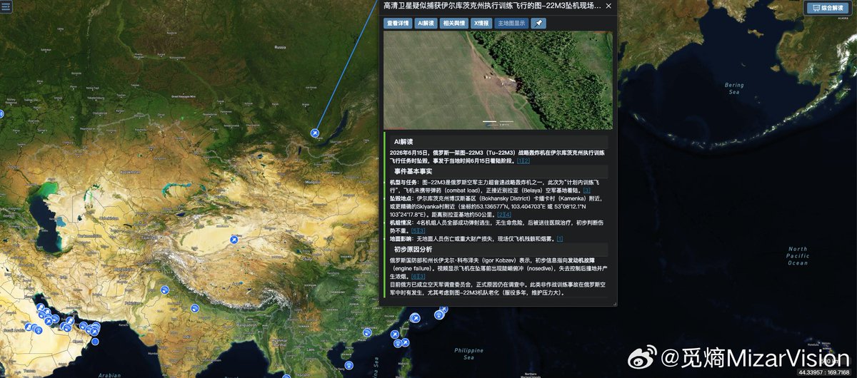
New high-resolution satellite imagery from MizarVision appears to show the crash site of a Russian Tu-22M3 “Backfire” bomber near Kamenka in the Irkutsk region, Russia. The aircraft crashed on June 15 during a training flight. Russian officials said the four-member crew ejected, the bomber was flying without a combat load, and preliminary information pointed to engine failure. The imagery provides a clearer view of the impact area and surrounding terrain, adding another OSINT data point to the tracking of Russia’s long-range aviation fleet. The Tu-22M3 remains one of Russia’s key Soviet-era strategic bomber platforms, capable of carrying long-range air-launched weapons including Kh-22 cruise missiles and Kinzhal hypersonic missiles. #MizarVision #OSINT #GEOINT #Russia #Tu22M3 #Irkutsk #MilitaryAviation

New high-resolution imagery from MizarVision shows the U.S. Navy aircraft carrier USS Abraham Lincoln operating in the Gulf of Oman. The carrier’s presence places a major U.S. naval asset near one of the world’s most sensitive maritime corridors, connecting the Arabian Sea, the Strait of Hormuz and the Persian Gulf. The imagery also highlights how commercial satellite monitoring and AI-assisted geospatial analysis are increasingly being used to track naval movements in near real time. 📸 MizarVision / MiEntropy #USSAbrahamLincoln #GulfOfOman #USNavy #GEOINT #OSINT


MizarVision reports that new high-resolution satellite imagery shows multiple US military aircraft deployed at Chania Ioannis Daskalogiannis International Airport on Crete, Greece. Visible aircraft reportedly include KC-135 aerial refueling tankers, RC-135 reconnaissance aircraft, and EA-37B electronic warfare aircraft. The presence of tanker, surveillance, and electronic warfare platforms at the same location highlights Crete’s growing role as a key operating hub for monitoring the Eastern Mediterranean, the Middle East, and North Africa. MizarVision says its MiEntropy system is being used to strengthen AI-assisted event analysis by connecting remote sensing data with faster operational intelligence. #MizarVision #Crete #Greece #GEOINT #OSINT


🇺🇦🛰️ New high-resolution imagery from Vantor, highlighted by @georgewbarros, shows damaged oil storage tanks at Rybinsk, collected on June 21. The site is reportedly linked to the Kombinat Temp oil depot in Russia’s Yaroslavl region, where Ukrainian drone strikes earlier targeted fuel infrastructure far beyond the immediate front line. This image matters because Rybinsk is not in occupied Crimea and not directly on the battlefield. It shows the depth of Ukraine’s expanding long-range strike campaign. Oil depots like this are not just storage sites. They are part of the wider fuel chain that supports Russia’s economy, military mobility, logistics planning, industrial operations, and war sustainment. When tanks are damaged, the impact can go beyond the loss of fuel itself. It can disrupt distribution, create repair burdens, reduce reserve flexibility, and force Russia to allocate more air defense and emergency resources to rear-area infrastructure. That is the broader pattern now visible across multiple recent strikes. Crimea, Kerch, Port Kavkaz, the Kerch Strait Bridge, Chonhar, Henichesk, Peredmistne, Stavky, and now Rybinsk all point to the same strategic logic: Ukraine is targeting the systems that keep Russia’s war machine moving. Bridges slow military movement. Oil depots pressure fuel supply. Ports and crossings expose logistics chokepoints. Road and rail damage complicates routing. Smoke generators on the Kerch Strait Bridge show Russia is trying to hide and protect key infrastructure from observation. Rybinsk adds another layer: pressure deep inside Russia’s own fuel network. The cumulative effect is the most important part. One damaged storage site can be repaired. One bridge can be bypassed. One road can be rerouted. But repeated strikes across fuel, transport, bridge, and port infrastructure force Russia into a constant cycle of defense, repair, concealment, rerouting, and resource diversion. That is exactly what a sustained logistics campaign is designed to do. Commercial satellite imagery is making this visible almost in real time. It allows observers to see not only where strikes happened, but how the pressure is spreading across Russia’s military-support infrastructure. Ukraine is not only hitting front-line targets. It is reaching into the rear of Russia’s logistics and energy system. And Rybinsk shows that the campaign is no longer limited to Crimea’s supply routes — it is also reaching deeper into the infrastructure that helps sustain Russia’s war. 📸 @vantortech / @georgewbarros #Ukraine #Russia #Rybinsk #Vantor #OSINT #SatelliteImagery #RussiaUkraineWar #OilInfrastructure #MilitaryLogistics #LongRangeStrikes

🇺🇦🛰️ New high-resolution imagery from Vantor, highlighted by George Barros, shows a fire at the oil storage facility at Port Kavkaz, collected on June 21. This is another major signal that Ukraine’s pressure campaign around the Kerch Strait is expanding beyond bridges and roads into the fuel infrastructure that keeps Russia’s military logistics moving. Port Kavkaz sits on the Russian side of the Kerch Strait, opposite occupied Crimea. Its location makes it strategically important: it supports maritime logistics, fuel handling, ferry-linked movement, and the wider transport system connecting Russia with the occupied peninsula. A fire at oil storage facilities in this area is not just local damage. It affects the fuel chain. Fuel is one of the most critical components of military sustainment. It powers trucks, armored vehicles, engineering equipment, generators, air defense systems, and logistics convoys. When storage tanks burn, Russia loses more than fuel volume — it loses flexibility, distribution capacity, and time. This strike also fits into the wider pattern seen across recent satellite imagery: damaged bridges, hit crossing points, damaged roads, burning storage tanks near Kerch, and smoke generator vehicles operating on the Kerch Strait Bridge. Taken together, these images show a clear operational theme. Ukraine is targeting the infrastructure that keeps Crimea connected, supplied, and militarily usable. The Kerch Strait area is especially vulnerable because it concentrates multiple critical nodes in one corridor: the bridge, ports, ferry routes, oil facilities, rail links, roads, and military transit routes. Damage in this area creates pressure across the entire system. Russia can repair roads. Russia can build alternate bridges. Russia can deploy smoke generators. Russia can reroute convoys. But every new hit forces another adaptation — and every adaptation costs time, resources, manpower, protection, and logistical efficiency. That is the cumulative effect. Ukraine is not only striking targets. It is forcing Russia into a constant cycle of repair, concealment, rerouting, and defense around one of the most important corridors supporting the occupation of Crimea. Commercial satellite imagery is making that process visible in near real time. The latest image from Port Kavkaz shows that the fuel side of Russia’s Crimea supply network is now under direct and sustained pressure. 📸 @vantortech / @georgewbarros #Ukraine #Crimea #PortKavkaz #KerchStrait #KerchBridge #Vantor #OSINT #SatelliteImagery #RussiaUkraineWar #MilitaryLogistics

🇺🇦🛰️ New high-resolution imagery from Vantor, highlighted by George Barros, shows damage to the Chonhar Bridge in Crimea, collected on June 12. This is not just another damaged crossing. The Chonhar Bridge is one of the key routes connecting occupied Crimea with Russian-held territory in southern Ukraine. For Russia, this corridor is part of the wider logistics network used to move fuel, ammunition, military vehicles, equipment, and personnel between Crimea and the occupied mainland. That is why damage here matters. Crimea’s military value depends on connectivity. The peninsula is supported by a limited number of major access routes: the Kerch Strait Bridge, road links through occupied Kherson and Zaporizhzhia, rail infrastructure, ports, fuel depots, and smaller bridge crossings such as Chonhar and Henichesk. When one of these nodes is damaged, Russia can reroute. When several are damaged across the same network, the pressure compounds. The latest imagery fits into a broader pattern visible in recent days: damaged bridges, hit border crossings, struck oil storage facilities near Kerch, smoke generator vehicles on the Kerch Strait Bridge, and new alternate crossings built to keep traffic moving. That tells the bigger story. Ukraine is not only targeting individual pieces of infrastructure. It is pressuring the entire logistics system that allows Russia to sustain its military presence in Crimea. Every damaged bridge forces repairs, delays, rerouting, added protection, engineering work, and more dependence on alternative routes. Every fuel site hit makes transport planning harder. Every exposed chokepoint becomes another vulnerability. The Chonhar Bridge is especially important because it sits on a practical military supply corridor, not just a symbolic route. Damage there complicates movement between Crimea and the occupied south at a time when Russia is already trying to protect the Kerch Strait Bridge and preserve fuel flows across the region. This is the cumulative logic of the campaign: hit the bridges, hit the roads, hit the depots, hit the fuel system, expose the chokepoints, and force Russia to spend more resources simply keeping Crimea connected. Commercial satellite imagery is making that process visible in near real time. Crimea is being treated less like a secure rear area — and more like a vulnerable logistics network under sustained pressure. 📸 @vantortech / @georgewbarros #Ukraine #Crimea #Chonhar #KerchBridge #Vantor #OSINT #SatelliteImagery #RussiaUkraineWar #MilitaryLogistics #BlackSea

🇺🇦🛰️ New high-resolution imagery from Vantor, highlighted by George Barros, shows damage to the Stavky Bridge over the North Crimean Canal, collected on June 20. This is another piece of the wider campaign targeting Russia’s logistics network around occupied Crimea and the occupied south of Ukraine. The Stavky Bridge may not carry the same symbolic weight as the Kerch Strait Bridge, but smaller crossings like this matter operationally. They form part of the road network that allows Russia to move supplies, fuel, equipment, vehicles, and personnel across occupied territory. In military logistics, every bridge is a potential node. Damage one crossing, and traffic can be rerouted. Damage several crossings, and the entire system becomes slower, more exposed, and harder to manage. That is the pattern now visible across multiple recent satellite images: damaged bridges, alternate crossings, border points, roads, oil storage tanks, and defensive measures such as smoke generators on the Kerch Strait Bridge. Taken together, these are not isolated images. They show a logistics system under sustained pressure. For Russia, Crimea depends on connectivity: the Kerch Strait Bridge, road links through occupied southern Ukraine, fuel depots, ports, storage sites, and smaller crossings that keep traffic moving when larger routes are threatened. Ukraine appears to be targeting that connectivity piece by piece. The importance of the Stavky Bridge lies in cumulative effect. A single damaged span may not stop Russian logistics on its own, but it forces repairs, rerouting, traffic delays, additional engineering work, and more defensive allocation. That means more time, more resources, and more vulnerability. Commercial satellite imagery is making this process visible in near real time. It allows observers to see not only where Russia has been hit, but how Russia is being forced to adapt: building alternate bridges, obscuring key infrastructure, and trying to preserve movement across a shrinking set of reliable routes. Crimea is being treated less like a fixed rear area and more like a vulnerable logistics network. And the latest imagery from the North Crimean Canal shows that pressure continuing. 📸 @vantortech / @georgewbarros #Ukraine #Crimea #Stavky #NorthCrimeanCanal #Vantor #OSINT #SatelliteImagery #RussiaUkraineWar #MilitaryLogistics #BlackSea

🇺🇦🛰️ New high-resolution imagery from Vantor, highlighted by George Barros, shows damage to the Henichesk Bridge and newly built alternate bridges, collected on June 21. This is another important piece of the wider picture around Crimea’s logistics network. The Henichesk crossing is not just a local bridge. It is part of the southern transport system used to move supplies between occupied parts of southern Ukraine and Crimea. For Russia, these routes matter because they provide alternative access points and backup corridors when other key links, including the Kerch Strait Bridge, come under pressure. The appearance of new alternate bridges is especially significant. It suggests Russia is trying to build redundancy into its supply network — creating additional crossings and bypass options to keep traffic moving even after strikes damage existing infrastructure. That is exactly what a military logistics system does when it expects repeated attacks: it repairs, reroutes, disperses, and builds alternatives. But the need for alternate bridges also reveals the problem. Ukraine’s campaign is increasingly focused on degrading Russia’s ability to sustain Crimea as a military hub. Roads, bridges, oil storage sites, rail links, ports, and chokepoints are all part of the same network. Damage to one point may be manageable. Repeated pressure across multiple points forces Russia to spend time, equipment, manpower, and air defense resources just to keep the system functioning. Henichesk matters because it sits in the broader land corridor supporting occupied Crimea. The latest imagery shows that Russia is not only defending major symbolic infrastructure like the Kerch Strait Bridge — it is also trying to preserve smaller but operationally important crossings that keep supplies moving across the occupied south. This is the real story behind the image: Ukraine is not only striking infrastructure. It is forcing Russia into a constant logistics adaptation cycle. Build. Repair. Bypass. Conceal. Defend. Repeat. 📸 @vantortech / @georgewbarros #Ukraine #Crimea #Henichesk #OSINT #Vantor #SatelliteImagery #RussiaUkraineWar #MilitaryLogistics #BlackSea #Geopolitics

🇺🇦🛰️ New high-resolution imagery from Vantor, highlighted by George Barros, shows damage at the Peredmistne border crossing point between occupied Crimea and Kherson, collected on June 17. This is another important node in Russia’s southern logistics network. The crossing sits on one of the routes linking occupied Crimea with Russian-held territory in Kherson. These routes are not symbolic only — they are part of the practical supply system Russia uses to move fuel, ammunition, equipment, military vehicles, and personnel between Crimea and the occupied mainland corridor. That is why damage at Peredmistne matters. Ukraine’s recent campaign has increasingly focused on the infrastructure that keeps Crimea connected: bridges, roads, checkpoints, fuel depots, oil storage sites, rail links, ports, and chokepoints. Each damaged crossing forces Russia to reroute traffic, slow movement, increase protection, repair infrastructure, and rely more heavily on alternative routes. The pattern is becoming clearer with every new image. Kerch shows the pressure on Russia’s main strategic bridge. Henichesk shows the pressure on alternate crossings. Peredmistne shows the pressure on the administrative and transport links between Crimea and occupied Kherson. Taken together, these are not isolated strikes. They are part of a broader effort to degrade the network that allows Russia to sustain its military presence in Crimea. A single damaged road or checkpoint may look limited on its own. But repeated strikes across multiple logistics nodes create a cumulative effect: longer routes, more bottlenecks, less reliable fuel movement, slower military transport, and greater strain on Russian command and supply planning. Crimea is being targeted not only as territory, but as a logistics system. And commercial satellite imagery is making that system visible — one damaged node at a time. 📸 @vantortech / @georgewbarros #Ukraine #Crimea #Kherson #Peredmistne #Vantor #OSINT #SatelliteImagery #RussiaUkraineWar #MilitaryLogistics #BlackSea

🇺🇦🛰️ New high-resolution imagery from Vantor, highlighted by George Barros, shows damage to the Henichesk Bridge and newly built alternate bridges, collected on June 21. This is another important piece of the wider picture around Crimea’s logistics network. The Henichesk crossing is not just a local bridge. It is part of the southern transport system used to move supplies between occupied parts of southern Ukraine and Crimea. For Russia, these routes matter because they provide alternative access points and backup corridors when other key links, including the Kerch Strait Bridge, come under pressure. The appearance of new alternate bridges is especially significant. It suggests Russia is trying to build redundancy into its supply network — creating additional crossings and bypass options to keep traffic moving even after strikes damage existing infrastructure. That is exactly what a military logistics system does when it expects repeated attacks: it repairs, reroutes, disperses, and builds alternatives. But the need for alternate bridges also reveals the problem. Ukraine’s campaign is increasingly focused on degrading Russia’s ability to sustain Crimea as a military hub. Roads, bridges, oil storage sites, rail links, ports, and chokepoints are all part of the same network. Damage to one point may be manageable. Repeated pressure across multiple points forces Russia to spend time, equipment, manpower, and air defense resources just to keep the system functioning. Henichesk matters because it sits in the broader land corridor supporting occupied Crimea. The latest imagery shows that Russia is not only defending major symbolic infrastructure like the Kerch Strait Bridge — it is also trying to preserve smaller but operationally important crossings that keep supplies moving across the occupied south. This is the real story behind the image: Ukraine is not only striking infrastructure. It is forcing Russia into a constant logistics adaptation cycle. Build. Repair. Bypass. Conceal. Defend. Repeat. 📸 @vantortech / @georgewbarros #Ukraine #Crimea #Henichesk #OSINT #Vantor #SatelliteImagery #RussiaUkraineWar #MilitaryLogistics #BlackSea #Geopolitics

New satellite imagery published by George Barros, citing @vantortech, shows damage to storage tanks near Kerch in occupied Crimea. This is not just another isolated strike on a fuel site. Kerch sits next to one of the most important logistics corridors supporting Russia’s occupation of Crimea. The area is directly tied to the Kerch Strait Bridge, port infrastructure, fuel movement, military transport, and the wider supply network connecting occupied Crimea with Russia. Damage to storage tanks matters because fuel is one of the core elements of military sustainment. Without reliable fuel flow, Russia’s ability to move vehicles, support air defense systems, supply units, rotate equipment, and maintain operational tempo becomes harder and more expensive. The imagery also fits into a broader Ukrainian campaign targeting Russian infrastructure across Crimea and parts of Russia, including bridges, roads, oil storage facilities, and key transport routes used to supply Russian forces on the peninsula. In recent imagery from June 22, multiple smoke generator vehicles were also seen operating on the Kerch Strait Bridge, apparently attempting to obscure parts of the roadway and bridge structure. That suggests Russia is increasingly concerned about surveillance, targeting, and possible follow-up strikes on its most symbolic and strategically important link to Crimea. The message is clear: Ukraine is not only attacking individual targets — it is pressuring the entire logistics system that keeps Russian forces in Crimea connected, fueled, and supplied. Crimea is being treated as a network of vulnerable nodes: bridges, depots, roads, ports, fuel tanks, and choke points. And satellite imagery is making that network visible in real time. 📸 @vantortech / @georgewbarros #Ukraine #Crimea #Kerch #KerchBridge #OSINT #Vantor #SatelliteImagery #RussiaUkraineWar #MilitaryLogistics #BlackSea


🇺🇦🛰️ New high-resolution imagery collected by Vantor shows visible damage to Russian infrastructure in occupied Crimea and parts of Russia, including bridges, roads, transport routes, and oil storage facilities. The strikes appear to be focused on the system that keeps Russian forces in Crimea supplied. This is not just about individual damaged sites. Bridges, roads, depots, and oil facilities form the backbone of Russia’s military logistics into the occupied peninsula. When those nodes are hit repeatedly, the impact spreads across fuel movement, equipment transfers, ammunition supply, repair work, convoy planning, and the overall tempo of Russian military activity in the region. One of the most important details comes from imagery collected on June 22. Multiple smoke generator vehicles were observed operating on the Kerch Strait Bridge, apparently attempting to obscure parts of the roadway and bridge structure from satellite observation. That is a significant visual indicator. The Kerch Strait Bridge remains one of Russia’s most strategic links to Crimea. It connects the Russian mainland with the occupied peninsula and remains central to Moscow’s military, political, and symbolic control over the area. Any visible attempt to conceal sections of the bridge suggests heightened concern around surveillance, targeting, or possible follow-up strikes. The wider Ukrainian campaign has increasingly focused on isolating Crimea by pressuring its transport and fuel network. Strikes against oil storage sites and key routes do not only damage infrastructure — they force Russia to adapt, reroute, ration, defend, and spend more resources just to maintain the same level of supply. Commercial satellite imagery is again playing a major role in documenting the battlefield. It exposes damage, defensive measures, logistics patterns, and movement around high-value targets in near real time. Crimea is not only being attacked as territory. It is being attacked as a logistics system. 📸 @vantortech #Ukraine #Crimea #KerchBridge #Vantor #OSINT #SatelliteImagery #RussiaUkraineWar #MilitaryLogistics #BlackSea #Geopolitics


@vanZuiden_Eric Occupied and end of story
Google Maps has recently updated imagery over the Crimean Bridge area, revealing Russian defensive measures in much higher quality, according to Oko Gora. The new view shows protective structures, barges positioned around the bridge to counter unmanned threats, and visible air defense positions near one of Russia’s most important logistics links to occupied Crimea. For OSINT analysts, this update gives a clearer look at how heavily Moscow is trying to shield the bridge after repeated Ukrainian strikes against Russian military and transport infrastructure in Crimea. #Crimea #CrimeanBridge #OSINT #Ukraine #Russia


🇺🇸⚓ Satellite imagery published by MizarVision appears to show the USS Boxer (LHD-4), a Wasp-class amphibious assault ship of the United States Navy, conducting replenishment activity in the Strait of Malacca. The location is highly significant. The Strait of Malacca is one of the world’s most important maritime chokepoints, linking the Indian Ocean with the South China Sea and the wider Western Pacific. Any visible movement of major U.S. naval assets through this corridor matters because it sits at the intersection of global trade, energy flows, regional security, and great-power competition. USS Boxer is not a small surface combatant. As an amphibious assault ship, it can support aviation operations, carry Marines, deploy landing craft, and function as a mobile sea base during crisis response, deterrence missions, evacuation operations, humanitarian assistance, and regional presence deployments. The imagery also highlights the value of commercial satellite monitoring. Open-source satellite data is increasingly capable of tracking naval activity, logistical patterns, route choices, and operational tempo across key maritime corridors. Even routine replenishment can provide insight into where a naval force is moving, how long it may remain deployed, and which strategic areas are being prioritized. This does not automatically indicate an imminent operation or escalation. Replenishment is a normal part of sustained naval activity, especially for large ships operating far from home ports. However, the presence of USS Boxer in this corridor underlines the continued importance of Southeast Asian sea lanes for U.S. military mobility and regional posture. The Strait of Malacca remains a critical artery for both commercial shipping and military transit. Monitoring activity there offers a clear view into how naval forces position themselves between the Indian Ocean, the South China Sea, and the broader Indo-Pacific theater. #MizarVision #OSINT #USSBoxer #USNavy #IndoPacific #StraitOfMalacca #SatelliteImagery #MaritimeSecurity #NavalTracking #Geopolitics


🛰️ MizarVision satellite observations show a large smoke plume rising over the Kerch Strait area after a reported Ukrainian strike on the Russian Port Kavkaz logistics hub. 📍Image coordinate marker: 45.33901, 36.46484 📍Area: Kerch Strait / Port Kavkaz–Kerch maritime corridor 📍Region: Krasnodar Krai, Russia / occupied Crimea interface 📅 Observation date: 21 June 2026 The imagery highlights three visible elements: port infrastructure or berth facilities, a dense smoke plume moving over the water, and at least one vessel inside or near the affected maritime zone. Port Kavkaz is one of the key Russian logistics points around the Kerch Strait, supporting ferry, fuel, cargo and military-related movement between mainland Russia and occupied Crimea. Any disruption in this area can affect maritime traffic, fuel handling and supply routes connected to the Crimean bridge corridor. The smoke signature is clearly visible on satellite imagery, but the exact scale of damage, type of material burning and confirmed target set still require additional confirmation from follow-up imagery and official statements. #MizarVision #OSINT #SatelliteImagery #UkraineWar #KerchStrait #PortKavkaz #Crimea #Russia #Geolocation


New high-resolution satellite imagery made by MizarVision / MiEntropy shows updated post-strike damage assessment around the Moscow Oil Refinery and nearby energy / industrial facilities in southeastern Moscow, Russia. Geolocation cluster: Moscow Oil Refinery / Kapotnya industrial area Moscow, Russia Main observed refinery zone: 55.65397°N, 37.80769°E Additional refinery / damaged infrastructure reference: 55.65874°N, 37.80610°E Nearby industrial / commercial facility: 55.65549°N, 37.83107°E The new imagery appears to show multiple affected storage tanks, damaged roof surfaces, darkened tank interiors, burn marks, smoke residues and possible blast-related surface disturbance across the refinery area. Several tanks are marked as damaged, while others remain visually intact, which helps narrow the affected sections rather than treating the whole facility as uniformly damaged. Visible / marked refinery indicators include: 1. Damaged storage tank 2. Damaged storage tank 3. Damaged storage tank 4. Heavily damaged storage tank 5. Damaged storage tank 6. Damaged storage tank 7. Intact storage tank 8. Intact storage tank 9. Intact spherical storage tank A separate image layer also identifies a large industrial / commercial building east of the refinery area, around 55.65549°N, 37.83107°E. The marked site shows a large roof structure, an affected building zone, smoke / water-stain signatures, and auxiliary structures. This suggests the post-strike damage footprint may extend beyond a single tank farm and into the wider industrial belt around Kapotnya. The important analytical point is timing. MizarVision shows imagery from June 19 and June 20, allowing comparison between the first visible aftermath and later updated collection. That matters because refinery strikes can create delayed visual indicators: smoke clears, burn patterns become sharper, damaged roofs become easier to separate from shadow, and tank-top deformation becomes more readable in high-resolution satellite imagery. From an OSINT / GEOINT perspective, this is a strong example of multi-time damage assessment: - first pass: identify the impact / smoke / fire zone - second pass: isolate damaged tanks and buildings - third pass: map related infrastructure and nearby industrial exposure - final assessment: separate confirmed visual damage from unconfirmed technical assumptions The coordinates visible in the MizarVision material place the main refinery damage inside the Kapotnya energy complex, with a second affected industrial site roughly 2.5 km to the east. Both locations sit inside Moscow’s dense southeastern industrial corridor, close to major roads, commercial areas, storage infrastructure and energy-related facilities. Assessment: Location confidence: high Visible refinery damage: moderate to high Tank-level damage identification: moderate Damage to nearby industrial / commercial facility: moderate Operational impact: requires external confirmation Exact strike mechanism for each object: unconfirmed from imagery alone Important note: The imagery supports an assessment of visible damage to refinery storage / processing infrastructure and a nearby industrial facility after Ukrainian drone attacks. It should not be used alone to assign exact technical causes to every damaged tank, roof, pipework section or building without pre-strike comparison, post-strike imagery and ground confirmation. MizarVision / MiEntropy continues to show how AI-assisted satellite analysis can turn complex strike aftermath into structured event intelligence by combining geolocation, time-series imagery, object recognition, damage indicators and post-event visual change assessment. #MizarVision #MiEntropy #OSINT #GEOINT #SatelliteImagery #Moscow #Kapotnya #MoscowOilRefinery #Ukraine #RussiaUkraineWar #DroneStrike #RemoteSensing #MizarVisionWatcher


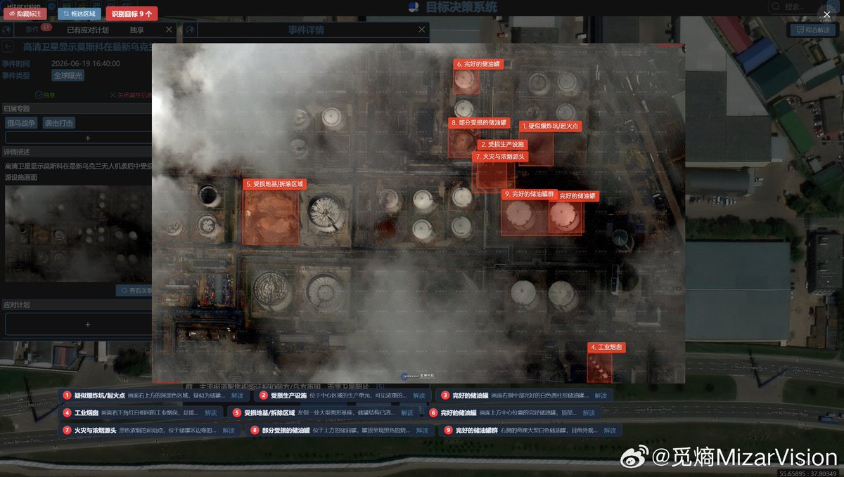
New high-resolution satellite imagery made by MizarVision / MiEntropy appears to show damage inside the Moscow Oil Refinery area in Kapotnya, Moscow, Russia, following the latest Ukrainian drone attack. Geolocation: Moscow Oil Refinery / Kapotnya district Moscow, Russia Approximate coordinates: 55.65895°N, 37.80349°E The most notable feature in the imagery is the apparent location of the “floating roof” / tank cover that was blown away during the explosion. In the satellite frame, MizarVision marks multiple points across the refinery complex, including suspected ignition / blast-related areas, damaged production infrastructure, storage tanks, fire and smoke sources, an industrial map reference, and the suspected displaced roof / cover zone. The visible scene shows a refinery section with heavy smoke cover, dark burn marks, damaged surface patterns and several highlighted storage / processing elements. Some tanks appear intact, while other marked zones show signs of impact-related disturbance or fire exposure. The cloud and smoke layer limits full visibility, but the marked objects suggest that damage was not confined to one isolated point. Key visible / marked features: 1. Suspected ignition or explosion point 2. Damaged production infrastructure 3. Intact storage tank 4. Industrial reference area 5. Damaged ground / suspected demolition or blast-affected zone 6. Intact storage tank 7. Fire and smoke source 8. Partially damaged storage tank 9. Intact storage tank group The coordinates visible in the MizarVision material place the observed site at approximately 55.65895, 37.80349, inside the Kapotnya refinery complex in southeastern Moscow. This is a strategically relevant energy facility because it is part of the fuel supply network serving the Russian capital and the wider Moscow region. From an OSINT / GEOINT perspective, the displaced “floating roof” is especially important. Tank roofs or covers can be moved by blast pressure, internal ignition, fuel vapor explosion, secondary detonation, or intense overpressure inside a storage structure. Locating the displaced roof helps analysts reconstruct the direction and force of the event, identify the most affected tank or process area, and compare the satellite scene with ground-level video evidence. The imagery also shows why post-strike satellite analysis matters. Public videos can show flames, smoke and dramatic explosion effects, but satellite imagery helps geolocate the damage, separate confirmed physical impact from visual speculation, and map the affected refinery components. Analytical confidence: Location: high, based on visible coordinate overlay and refinery layout Visible damage indicators: moderate to high Exact cause of each marked damage point: unconfirmed from imagery alone Extent of operational disruption: requires additional confirmation Military or industrial function of each specific marked component: partially assessed, not fully confirmed Important note: The imagery supports an assessment of visible damage inside the Kapotnya refinery area after a Ukrainian drone attack. It should not be used alone to assign exact technical failure mechanisms to every tank, pipework section or production unit without additional pre-strike imagery, post-strike imagery and ground confirmation. MizarVision / MiEntropy continues to show how AI-assisted satellite analysis can turn complex strike aftermath scenes into structured event intelligence by combining geolocation, object detection, damage indicators and visual change assessment. #MizarVision #MiEntropy #OSINT #GEOINT #SatelliteImagery #Moscow #Kapotnya #MoscowOilRefinery #Ukraine #RussiaUkraineWar #DroneStrike #RemoteSensing #MizarVisionWatcher

New satellite imagery made by MizarVision / MiEntropy appears to show damage to a logistics / warehouse facility area in Kyiv Oblast, Ukraine, following a Russian attack. Geolocation: 50.38931°N, 30.79467°E Approximate area: Prolisky / Boryspil district, Kyiv Oblast, Ukraine East of Kyiv, near the wider Kyiv–Boryspil logistics and commercial corridor. The MizarVision layer marks several relevant features inside and around the observed site: 1. Industrial / warehouse-type building 2. Dense residential area nearby 3. Large warehouse building 4. Damaged building complex 5. Separate industrial / utility-type facility The most important point is the proximity between the suspected damaged structure and civilian / commercial surroundings. The imagery does not only show an isolated industrial object. It shows a mixed environment where logistics buildings, residential blocks, warehouses and local infrastructure sit close to each other. Damage indicators visible in the satellite view include disturbed roof / surface patterns, darker affected sections and a highlighted building complex that appears to have sustained visible impact-related damage. Cloud cover and haze reduce full visual clarity, so the assessment should remain careful: the imagery suggests damage, but exact structural severity would require additional before / after imagery or ground confirmation. From an OSINT / GEOINT perspective, this location matters because logistics centers around Kyiv Oblast are part of Ukraine’s rear-area supply, storage and distribution network. Even when a target is not directly on the front line, damage to warehouse or logistics infrastructure can affect transport flows, commercial supply chains, humanitarian movement and local recovery operations. The coordinates visible on the MizarVision material point to the area around: 50.38931, 30.79467 That places the observed site in the eastern Kyiv Oblast urban-industrial belt, close to major roads and commercial infrastructure. This is exactly the type of rear-area zone where satellite-based damage assessment is useful, because local reporting may confirm that an attack occurred, while imagery helps narrow down where physical damage is visible. Important analytical note: The imagery should not be used alone to claim military use of the site. What can be assessed from the available material is physical damage to a logistics / warehouse-type area after a Russian attack, with nearby residential and industrial features also visible in the same frame. Confidence: Location: high, based on visible coordinate overlay Damage indication: moderate to high, based on marked satellite features Exact function of the damaged building: moderate Military relevance: unconfirmed from imagery alone MizarVision / MiEntropy continues to show how AI-assisted satellite analysis can turn raw remote sensing data into event-level intelligence, especially in fast-moving strike aftermath situations where timing, geolocation, object classification and damage indicators all matter. #MizarVision #MiEntropy #OSINT #GEOINT #SatelliteImagery #Ukraine #KyivOblast #RemoteSensing #RussiaUkraineWar #MizarVisionWatcher


New infrared satellite material made by MizarVision / MiEntropy shows the aftermath area of the B-52H Stratofortress crash at Edwards Air Force Base in California, United States. Approximate geolocation: Edwards Air Force Base, Mojave Desert, California, United States Airfield reference: 34.9054°N, 117.8837°W Approx. main runway / observed crash area: 34.906°N, 117.884°W The aircraft was connected to the 412th Test Wing test environment and was on a test mission when it crashed shortly after takeoff. MizarVision’s infrared tracking is especially valuable here because the visible wreckage field appears extremely degraded, while thermal data can still separate residual heat signatures from the surrounding terrain. According to the MiEntropy layer, the main debris was already cold, but detectable thermal signals remained in the impact area. That suggests the infrared channel was still able to identify localized heat anomalies after the most intense fire phase had passed. In practical OSINT terms, this helps narrow the probable debris / burn zone even when conventional optical imagery shows only a darkened scar, scattered remnants, or low-contrast terrain disturbance. The imagery also captured a low-Earth orbit satellite passing over the same region at the same time. That is a useful reminder that modern event analysis is no longer only about one image. Timing, sensor type, orbital geometry, residual heat, smoke patterns, runway alignment and post-event ground signatures all matter. Important note: the reported tail number 60-0061 appears in OSINT/MiEntropy-linked material, but unless confirmed by official U.S. Air Force channels, it should remain marked as unconfirmed. Why this matters: Infrared collection can preserve analytical value after visible evidence becomes limited. In this case, the post-crash thermal layer may help define the affected area, distinguish hot spots from cold debris, and support a more precise reconstruction of where the B-52H came down near the Edwards airfield. MizarVision / MiEntropy continues to show how AI-assisted remote sensing can bridge the gap between raw satellite data and event-level intelligence. #MizarVision #MiEntropy #OSINT #GEOINT #SatelliteImagery #B52 #B52H #EdwardsAFB #USAF #AviationSafety #RemoteSensing #MizarVisionWatcher


Berend @Berend73536023
1 Followers 132 Following
أسامة محمد @smmmd264381
0 Followers 47 Following

Tommy @Tommy615646028
29 Followers 552 Following
ForTheFriends @ForTheFriends
8 Followers 226 Following 歴史好き、でも年号を覚えられないv(^_^v)♪ 土方歳三さんと小栗忠順さんが大好き。維新の倒幕派は嘘つきばかりで大嫌い。プロフィール画像は永江一石 @isseki3 さんのブログ http://t.co/4C63jcXoR6 から頂きました←エセ愛国じゃないよw
AghaJavadDossetDarim6... @Uncle_STULIN
211 Followers 569 Following (إِنَّ الإِنسَانَ لَفِي خُسْرٍ) موتور گازی میرود، نظام سیاسی هم میرود، تفاوت این دو در چیست ؟! Nessie/Ness
Hossam Elashry @HossamElashry18
515 Followers 632 Following لا الاه الا انت سبحانك أنى كنت من الظالمين ❤️mansora university for engineering
azraoen @zdweresdetye
0 Followers 16 Following
『 Bandar 』 @iSaudi_
14K Followers 4K Following
m.hadi @darbache714
97 Followers 1K Following
Victor T. @Ha34878569
8 Followers 685 Following
Titus.Fl_Vespasian @Titus_F_V
285 Followers 285 Following Interested in geopolitics and geo-economics.
Mehdi H. @mhmiranusa
30K Followers 477 Following Cited by Forbes, USNI, Newsweek, TWZ, AOL, Bellingcat, Maritime-Executive, FleetMon, National Post, Haaretz, J Post, ToI, VOA, Maariv, Business Insider, ...
Pierre Colonna @PColonna14141
28 Followers 811 Following
That's Why I tweets @Preci_0n001
33 Followers 3K Following
JG1TPB @jg1tpb
296 Followers 5K Following
Pilou @Pilou_jdn
0 Followers 9 Following
harun danar @Rockn6Roll
0 Followers 156 Following
shubham Kumar @shubham41169114
0 Followers 39 Following
Nemesis @00Nemesis0
270 Followers 315 Following ای کاش مسئولیت پذیری بعضی ها به اندازه والضالین کشیدنشان بود....
sauvan @sauvan34948665
7 Followers 380 Following
Ernest Mokaor @EMokaor28931
0 Followers 30 Following
Seda Al A @Seda_AlAfdal
32 Followers 921 Following
Easyfrags @Easyfrags1
9 Followers 260 Following Chemistry - CSGO - Programming - Reverse engineering - Physics
Lidvine @Lidvine4
5 Followers 87 Following
Wellwisher @Wellwisher42503
0 Followers 207 Following

Hashir Abbas @hashirabbas86
0 Followers 79 Following
Mohammad zza @mohammadz988
6 Followers 345 Following
Yousef A @alawa_yous26886
17 Followers 195 Following
Canal del Mar @CanaldeAprocean
21 Followers 1K Following La Asociación para promover los océanos tiene como fin promover y difundir en España, Europa e Iberoamérica el conocimiento histórico-naval y la I+D+I marina
LIMON @limondar0
14K Followers 1K Following
FILIPPO FAIT @FaitFilippo
40 Followers 3K Following
Bernd Gerhard @Bernd_239
27 Followers 231 Following
Zhunan @nanxiangzhu55
455 Followers 7K Following
Mohd Fazlie @fazliezuber
9 Followers 70 Following
Zoon Geopolitikon @ZoonGeopolitiko
264 Followers 4K Following Opinólogo de café y bar; analista de nada y mucho; difusor de noticias internacionales.
okkokkokok @lvaaaaaar
57 Followers 6K Following
Romuha220176 @Romuha_220176
146 Followers 2K Following
Samyar @Samyar969
0 Followers 55 Following

PMo @MttPhil
35 Followers 230 Following
宇和川 龍 / Ryo U... @ryo_uwagawa
548 Followers 3K Following Keio Univ. 🇯🇵 | 防衛テックスタートアップを設立中 | Space / Arch / Marine Drone | Lab: @pslab_keiosfc ,Space Policy | NEDO-NEP 開拓コース'26 | Former Lead, @CanSat_FUSiON
VintageTR @trvintage
3 Followers 451 Following
non @non1926185
0 Followers 3K Following
Mateusz Narewski @NarewskiMateusz
2 Followers 120 Following
Jeremy Manning @jtmanning
196 Followers 2K FollowingTrends for United States
You might like